The Blackfeet Indian Reservation was established by the Treaty of 1855. It once was a much larger land base for the Tribe moving out southward and along the eastern slopes of the Rocky Mountains and to the Yellowstone River and northward out to North Saskatchewan River in Canada. The present reservation encompasses about 1.5 million acres (2,400.56 square miles) in northwestern Montana and is situated in Glacier and Pondera counties.
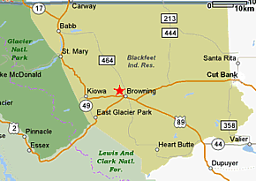
The reservations boundaries are: Canada to the north, Lewis and Clark National Forest to the south, Glacier National Park to the west, Toole County to the east. The major reservation communities are: Browning, Heart Butte, Starr School, East Glacier, Blackfoot, Seville, St. Mary, and Babb.
The reservations boundaries are: Canada to the north, Lewis and Clark National Forest to the south, Glacier National Park to the west, Toole County to the east. The major reservation communities are: Browning, Heart Butte, Starr School, East Glacier, Blackfoot, Seville, St. Mary, and Babb.
